Permalink
GeoGirafe has permalink parameters used to configure in the URL what should be done when the application starts. This allow to load the map to a specific location and zoom, display a tooltip, ...and some other cool features.
All those parameters take precedence with configureation coming from the configuration or from a shared state of the appliation. Once applied, the parameters will be removed from the URL.
The following parameters are implemented:
Start Position and Zoom
map_x and map_y can be passed either in the local projection set in map.srid, or in decimal degrees (EPSG:4326).
Please not that all those 3 parameters should be given. You cannot just use map_x and map_y for example, you always have to use the 3 parameters together.
| Name | Description |
|---|---|
| map_x | X coordinate |
| map_y | Y coordinate |
| map_zoom | Zoom level of the map |
Example:
Crosshair, Tooltip and Marker
When using map_crosshair, map_tooltip or map_marker, the parameters map_x, map_y and map_zoom also must be given in the URL. The parameters map_marker_size and map_marker_offset are optional, and they are ignored if the parameter map_marker is not set.
| Name | Description |
|---|---|
| map_crosshair | When set to true, a crosshair will be added at the center of the map |
| map_tooltip | A tooltip containing the configured text will be added at the center of the map |
| map_marker | A marker with the provided icon will be added at the center of the map |
| map_marker_size | Optional marker size. The value must contain two numbers separated by a comma: width,height |
| map_marker_offset | Optional marker offset. The value must contain two numbers separated by a comma: x,y |
Example:
- https://demo.geomapfish.dev/mapbs/?map_x=2610789.2&map_y=1268289.3&map_zoom=6&map_tooltip=I%27m%20blue%20!
- https://demo.geomapfish.dev/mapbs/?map_x=2610789.2&map_y=1268289.3&map_marker=https://map.cartoriviera.ch/static/338598/apihelp/img/parking.png
- https://demo.geomapfish.dev/mapbs/?map_x=2610789.2&map_y=1268289.3&map_zoom=6&map_marker=https://map.cartoriviera.ch/static/338598/apihelp/img/parking.png&map_marker_size=32,32&map_marker_offset=16,32
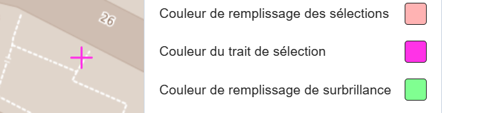
It's possible to change the crossair color in the configuration options:
Search
A search will be started with the content of the parameter. The first result will be selected on the map.
| Name | Description |
|---|---|
| search | The search term |
Examples:
Redirection to mobile or desktop interfaces
You can force to keep an interface (for instance use a desktop interface on mobile and vice versa) with the no_redirect param.
| Name | Description |
|---|---|
| no_redirect | Do not need a value but you can put one if you like it :) |
Default layers
The application can be initialized with default content (basemap, themes, groups, layers) using the following parameters:
| Name | Description |
|---|---|
| themes | The list of themes to add to the treview |
| groups | The list of groups to add to the treview |
| layers | The list of layers to add to the treview |
| basemap | The basemap |
themes, groups and layers parameters can contain a list separated by comas.
groups and layers with be activated by default. But if their name begin with !, the group or layer will be deactivated by default.
Those parameters will prevail to the default configuration of the application.
For example the default theme won't be loaded when defining a theme, group or layer in the URL.
Examples:
- https://demo.geomapfish.dev/mapbs/?groups=Tagesfamilien,Historische Parzellenpläne farbig
- https://demo.geomapfish.dev/mapbs/?basemap=Grundkarte grau
- https://demo.geomapfish.dev/mapbs/?groups=Velostadtplan
- https://demo.geomapfish.dev/mapbs/?groups=!Velostadtplan
Layers configuration
When add layers using the Permalink, there is also the possibility to configure them, and to set their default opacity, filter and time configuration.
The configuration options are specified in the URL as part of the layer or group parameter, separated by the | character. The first part of the parameter is the layer or group name, followed by configuration options.
The configuration options are separated bu the character ;.
Here are the available configuration options:
| Option | Description | Example |
|---|---|---|
| o | Sets the opacity of the layer (0 to 1) | o;0.5 |
| f | Applies a filter to the layer. The format of the filter is property;operator;value;type.If not specified, the default type is string. | f;gr_gz_kantypbez;eq;S1 |
| t | Sets a time restriction on the layer | t;2020/2024 |
Possible values for the filter operator : eq, neq, like, nlike, gt, gte, lt, lte.
These options can be combined in a single URL parameter.
Examples:
- https://demo.geomapfish.dev/mapbs/?layers=GR_Grundwasserschutzzonen|o;0.4|f;gr_gz_kantypbez;eq;S1
- https://demo.geomapfish.dev/mapbs/?layers=LF_Bildmittelpunkt_SchwarzWeiss|t;1954/1976
WFS Query
The wfs_ parameters will be used to initiate a WFS query with the information given. The map will zoom on the selected object after querying it.
| Name | Description |
|---|---|
| wfs_layer | The technical name of the layer |
| wfs_[column_name] | [column_name] must be the column name corresponding to the configured wfs_layer. The comparaison is done with a strict equality: wfs_layer=[layer] and wfs_column=[value] |
Examples:
UI-Components
You can control the visibility of some parts of the UI by adding the corresponding parameters and setting them to false.
| Name | Description |
|---|---|
searchVisible | Controls the visibility of the search bar in the top area of GeoGirafe: |
basemapVisible | Controls the visibility of the basemap selection component in the bottom left area of the map: |
Examples: